In exploring ways to visually show the migration route of an
ancestor, I have chosen an easy way. Just use the directions function on Google
Maps. Start with their starting point and add each leg of their migration to
the directions until you arrive at the last place they settled.
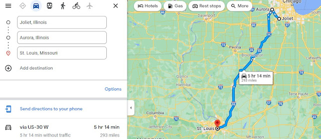
Hork Family. Here is an example. My great-grandfather emigrated from
Germany and the first place I locate him in records is in Joliet, Illinois when
he married my great-grandmother. I entered Joliet, Illinois in the get
directions box. To choose another direction, you’ll have to exchange Joliet’s
position to the top using the little arrows to the right.
He next lived in Aurora, Illinois, where he obtained his U.S. citizenship. So, I add Aurora as the next destination. While you do this, keep track of the number of miles between locations. It is 23 miles between Joliet and Aurora by automobile. You might want to move the route to make it most direct, as our ancestors did not have interstate highways and Google Maps usually points the route on highways. You could also choose the bicycle or walker symbol to pick the route.
He next lived in St. Louis, Missouri, so choose the “add a direction” and enter St. Louis. This route looks direct, so I’ll keep it.
I’ll keep adding directions of all the places he lived, using records of his as well as records of the children’s birthplaces. They lived in Detroit and Grand Rapids in Michigan; Stuart in Iowa; Portland, Oregon; Hamilton, Montana; and he died in Sheridan, Wyoming. Here is the final map.
Gorrell Family. I did the same for two other family members. The Gorrell
family began in Beaver County, Pennsylvania, traveled to Ross County, Ohio,
then to Blackwater and Joplin, Missouri, and my father-in-law moved to Glendale,
California, and finally to Sacramento, California. I did not include the three
years in England during World War II as that would have made map the map cover
too much area.
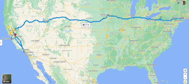
Nilsen Family. My husband’s great-grandfather was a minister and their family traveled a lot as he ministered at many churches. This map begins at Sheffield, Pennsylvania which isn’t labeled but you can see the white dot in western Pennsylvania. He next served in Youngstown, Ohio before going to Cromwell and New Britain in Connecticut. His next service was in Harcourt, Iowa, and then to Hilmar, California. The portion in California got a little crazy and I need to make just a map of the places in California only.
From Hilmar he went to San Pedro, then Escalon, then Santa Cruz, and finally returned to Hilmar where he retired.
It is still difficult to see the order and it would be nice
to have separate colors or numbers. There might even be better ways to do this,
but for a quick map showing migration, one cannot beat a Google Map using the
directions feature.
#52Ancestors-Week 36: Exploration
This is my fifth year working on this year-long prompt, hosted by Amy Johnson Crow (https://www.amyjohnsoncrow.com/) at Generations Cafe. I write each week on one of my two blogs, either Mam-ma’s Southern Family or My Trails into the Past. I have enjoyed writing about my children’s ancestors in new and exciting ways.


Yes, a really good, simple way to use Google Maps to follow our ancestors' travels! After I take a screen shot of my map with the route marked, I add (using photo software, directly on the image) more info such as dates of each move.
ReplyDeleteThat's a great idea and makes the map more useful.
Delete